Let's shed some light on your search


Welcome To Annapolis County
The County of Annapolis is pleased to present the Annapolis County Outdoor Recreation Map. The purpose is to showcase outdoor recreation opportunities that will inspire and encourage residents and visitors to explore the County and have fun planning active outdoor adventures during all four seasons.
It is meant to support an active outdoor network happening across Nova Scotia, and indeed Canada, aimed at getting folks moving in nature and in the great outdoors.
Discover Annapolis County safely and respectfully exploring the following landscapes: From the Annapolis Valley, North Mountain, the Bay of Fundy coastal region and the inland waterways and wilderness areas of the South Mountain, there is something for everyone.
We wish you lots of good fun as you create new memories one adventure at a time!
Contact Annapolis County Recreation for more information on programs, equipment rentals and other recreation opportunities. rec@annapoliscounty.ca
Learn more and share your adventures! For full size versions of the map Click Here
Copies of the Outdoor Recreation Map are available for free at the Visitor Information Centres or any one of the three Annapolis County municipal offices located in Annapolis Royal, Bridgetown and Lawrencetown.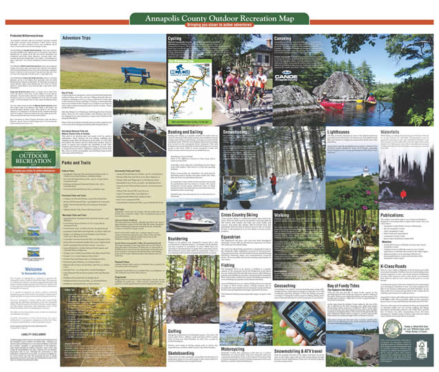
Safety Tips
- Check weather forecasts and always carry a map, compass, GPS, knife, matches, first aid kit, extra food and water.
- Tell someone where you are going and when you plan to return
- Wear appropriate clothing/equipment for the outdoor adventure.
- Check tide tables if planning a hike along the Bay of Fundy.
- Do not feed or approach animals in the wild.
- Be aware of the Forest Fire Index.
- Be aware of black flies in the spring and plan accordingly. The new bug nets work well!
- Ticks are common in the region, so make sure you do a daily tick check.
- Cell phones are great but not all areas of the county have reliable reception.
- Avoid introducing or transporting non-native species, both plants and aquatic.
- Practice no trace activities when traveling - please do not litter, pack it in and out!
- Be respectful of public and private lands when planning trips.
- Learn more and be prepared: AdventureSmart.ca
- Call 911 in an emergency.
Canada's Alert Ready
As of April 6, 2018, Canada's Alert Ready services will be available to compatible mobile devices. Alert Ready will broadcast emergency alerts to inform you of critical or potentially life threatening situations that require immediate attention to keep you and your family safe. To learn more about the Alert Ready service and what devices are supported, please visit: https://www.alertready.ca/
Protected Wilderness Areas
The province's wilderness areas are provincially significant protected areas which represent typical examples of Nova Scotia's natural landscapes, our native biological diversity and outstanding natural forests. Five wilderness areas lie within Annapolis County.
The 103,780 hectare Tobeatic Wilderness Area is the largest remaining wild area in the Maritimes, spanning parts of five counties. The region is characterized by unique barren and semi-barren landscapes with outstanding undisturbed glacial landforms, including esker fields, moraines, kettles and outwash plains. The Tobeatic is interconnected by lakes, streams and rivers, offering outstanding wilderness camping and hiking.
The 180 hectare McGill Lake Wilderness Area protects an outstanding wetland with diverse plant communities and scattered forest habitats within the South Mountain Rolling Plain natural landscape in Annapolis County. It features a diverse complex of bog and fen types, and forest communities of maple-oak-birch, and spruce-fir-pine/maple-birch.
The 10,830 hectare Cloud Lake Wilderness Area protects a significant headwater portion of the LaHave River watershed within the South Mountain Rolling Plain natural landscape. This landscape is an expansive granite bedrock, upland region characterized by a variety of forested landforms, glacial deposits, large scattered lakes, steep-sided streams and wetlands.
Scrag Lake Wilderness Area protects a remnant tract of intact forest within the heavily settled and farmed LaHave Drumlins Natural Landscape. The area protects lakes and surrounding woodlands. This includes a number of drumlins (elongated hills with good soil) which support impressive Acadian forest of sugar maple, hemlock and yellow birch.
The most recent edition includes the Medway Wilderness Area which now protects many of the paddling areas located in the County. The diverse and quality habitats support many species at risk, including blandings turtle, snapping turtle, american marten, mainland moose, and several bird species. Impressive stands of old sugar maple, yellow birch, white pine, and hemlock forest are scattered throughout.
More information on these Protected Wilderness Areas and Nature Reserves can be found on the NS Department of Environment and Labour website at www.gov.ns.ca .
Bay of Fundy
Coastal regions in Annapolis County are dotted with small tidal pebble beaches and rocky outcrops. Hiking along the shore is certainly a challenge, but it is a unique adventure; locals refer to this activity as beach combing or racking. A reasonable flat easy one is located at the Young's Cove Coastal Access Park. Be sure to take a camera and pack a picnic lunch or snack. Please watch the tides!
Hike the Delaps Cove Wilderness Trail along the Bay of Fundy shore. There are two trails, Bohaker and Charlies, and if you are looking for an extra adventure, return from Charlies Trail along the Bay Shore.
Many of the local wharves/beach areas provide coastal access or you can look for designated public parks along the shore.
Kejimkujik National Park and Natural Historic Site of Canada
This park is an absolute gem and much loved by outdoor enthusiasts. “Keji” answers all your hiking, paddling and camping needs. Plan an afternoon at the park, or a few days and explore the history and the wilderness reaches. There is much to explore that includes the waterfalls at Mill Falls, Hemlock and Hardwood hiking trail, biking to Mason's cabin or along the Mersey River, nighttime exploration of the Dark Sky, tours of native petroglyphs, and paddling along ancient waterways of the Mi'kmaw.
Annapolis County Parks and Trails
- Federal Parks
- Kejimkujik National Park and National Historic Site of Canada, 3005 Main Parkway, Maitland Bridge
- Fort Anne National Historic Site, 323 St. George Street, Annapolis Royal
- Melanson Settlement National Historic Site, 3870 Granville Road
- Port-Royal National Historic Site, 53 Historic Lane
Provincial Parks and Trails
- Cottage Cove Provincial Park, 11935 Shore Road East
- Mickey Hill Provincial Park, 7956 Highway 8, Graywood
- Valley View Provincial Park, 960 Hampton Mountain Road
- Belleisle Marsh Trail, (Near Little Brook Lane)
Municipal Parks and Trails
- Annapolis River Causeway Park and Boat Launch, 4468 Highway 1
- Grant Potter Memorial Park, 167 St. George Street, Annapolis Royal
- French Basin Trail- 112 Prince Street, Annapolis Royal
- Annapolis Youth Skate and Dog Park, 112 Prince Albert St.
- Delaps Cove Wilderness Trail (Bohaker and Charlies Trail), 2077 Shore Road West
- Cornwallis Veterans Memorial Park, 266 Spinnaker Drive
- Raven Haven Beachside Family Park, 2239 Virginia Road
- Hebb's Landing Park and Boat Launch, 7464 Hwy 1
- Queen Elizabeth 11 Jubilee Park and Boat Launch, 228 Granville Street, Bridgetown
- Youngs Cove Coastal Access Park, 6169 Shore Road West
- Young's Cove Coastal Adjunct, Shore Road
- Nictaux Park and Playground, 15 Old Runway Drive
- Nictaux Scotney Pathway, 101 Orchard Drive
- Shannon River Canoe Access Park, 4081 Hwy 10, Albany Cross
- Old Mill Trail - 213 Adam Drive, South Farmington
- Lake Pleasant Park and Boat Launch, 808 Lake Pleasant Road
- Middleton Riverside Park, 80 Bridge Street
- Middleton Rotary Raceway Park, 337 Marshall Street
- Middleton Centennial Park, 41 School Street
Community Parks and Trails
- Annapolis Royal Historic Gardens, 441 St. George Street
- Nictaux Falls Park and Picnic Area, 8950 Highway 10
- Springfield Union Picnic Grounds, 122 Hastings Road
- Lawrencetown Park and Boat Launch, 12 Lawrencetown Lane
- Bishop Park, Round Hill, 1351 Hwy 201
- Upper Clements Parks, 3041 Highway 1
- Margaretsville Willet Park, Haddock Alley
- Port Lorne Community Park
- Clementsvale Community Park, 3434 Clementsvale Road
Rail Trails
Annapolis County has two former rail lines that have been turned into recreation trails. Visit AnnapolisCounty.ca for more information.
Harvest Moon Trailway
The Harvest Moon Trailway officially opened in 2017 and is approximately 115 km of trail that links the many Annapolis Valley communities between Annapolis Royal, Annapolis County to Grand Pré, Kings County.
Much of the trail is multi-use, so please expect to see a variety of trail users along the way. Plan to hike and bike along this historic pathway which was known as the Dominion Atlantic Railway (CP).
South Shore Annapolis Valley Recreational Trail
This approximately 47 km long trail in the county follows along the path of the former CN Rail Line. It runs south of Middleton and connects to the Lunenburg County line into New Germany. It passes by the Nictaux Dam and holding pond, and by many wilderness lakes and streams and it is multi use.
Physical Fitness
Joining a fitness club or gym is a fantastic way to prepare for your next outdoor adventure.
Check the Fundy YMCA at Cornwallis Park, 1043 Highway 1 or visit Valleyconnect.ca for other choices.
Playgrounds
Playgrounds are located at most elementary schools and are available for public use. Check out the community events guide for a yearly updated list located throughout the region.
Cycling
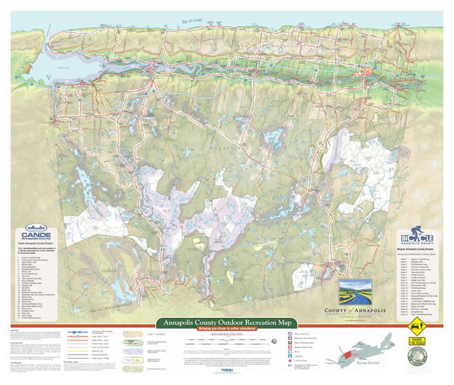
Bicycle Annapolis County - A Cyclist's Guide to Outdoor Adventure is available free of charge in hard copy and online at AnnapolisCounty.ca. The guide lists 22 colour-coded bicycle routes ranging from easy to moderate to challenging. It is especially designed for novice map readers and includes safety tips, Nova Scotia's bicycle laws, and other cycling information. Use it to plan a cycling adventure. You will find Share the Road signs through the county as we believe in safe shared use of public highways for walkers, cyclists and motorists.
Boating and Sailing
Boating and sailing is a popular pastime for many and our county's waterways offer many summer time traditions at local cottages and cabins to adventures on along our rivers and the Annapolis Basin. With the new floating docks and boat ramps now located at the Annapolis River Causeway Park and Bridgetown's Queen Elizabeth II Jubilee Park there is now easy access to this river. Refer to Canoe Annapolis County and Public Access to Waterways for more detailed access.
Boat Ramp or Access Point?
What is the difference between a boat ramp and a water access point?
Generally a boat ramp has a launching area for larger boats with trailers. Often there is a dock and mooring facilities.
Water access points are intended to be used only for launching canoes, kayaks, and other small craft. Often there are few or no amenities in the area.
In Annapolis County, these access areas have been used for generations and are known to locals. The Canoe Annapolis County guide references many of these locations in the route descriptions, and many have been identified on the county map.
Detailed map route descriptions are on line and free to download.
Bouldering
Thanks to the glacier era, Annapolis County has a rich concentration of “glacial erratics”, or boulders. Rock climbers can find a myriad of “problems” to solve. While there are currently no developed sites on public land, some land owners allow informal access when asked for permission. There is a new climbing wall located in Annapolis Royal at the Academy.
Golfing
Annapolis County has two 18 hole golf courses: Fort View Golf Course 3816 Hwy 1, Allain's Creek and Eden Golf & Country Club, 53 Hwy 201, West Paradise, as well a Par 3 course in South Farmington.
Practice your swing at driving ranges such as Action Jax, Granville Ferry or Eden Golf & Country Club, West Paradise.
Skateboarding
There is lots of youth excitement around this activity and as of publication, there are two skate parks in the county which are located in Middleton and Annapolis Royal.
Snowshoeing
Snowshoeing is a great way to enjoy the outdoors during the winter season and it burns more calories than walking or cycling.
Learning to snowshoe is easy and it's fun for the whole family. If you would like to try snowshoeing, contact your local recreation department and sign out a pair for you and/or a family member for free or sign up for one of the many programs hosted through the season.
Cross Country Skiing
Cross country skiing is a traditional winter time activity for many. There are many spots in Annapolis County just right for this activity that include rail trails, old roads, fields, golf courses, and parks like Mickey Hill Provincial Park and Kejimkujik National Park & Natural Historic Site of Canada. Be sure to ask permission if you are skiing on/across private property.
Equestrian
The abandoned rail lines, old roads and trails throughout Annapolis County offer an adventurous experience for those who wish to go horseback riding.
The centre for all activities equestrian in Annapolis County is the Annapolis Valley Exhibition Grounds in Lawrencetown. 4H groups meet there, and the facility hosts an annual farming exhibition featuring music and entertainment, livestock shows. There are public and private training opportunities in our county.
Fishing
The Annapolis River is an estuary, so fishing is a popular pastime in the Annapolis Royal and Bridgetown areas where one can catch both fresh and salt water species. Shad fishing is popular near Middleton and other regions along the Annapolis River. Many folks ice fish in the winter. Fly fishing and minnow or worm fishing are popular on the inland waterways.
A general fishing license or a salmon fishing license is required to angle in Nova Scotia waters. Fishing licenses can be purchased at many small stores in Annapolis County and there are the rules and regulations and ages required for licenses.
The freshwater fishing season generally begins on April 1 each year.
Motorcycling
Annapolis County has numerous roads that are a perfect destination for motorcyclists. Pick your adventure and your community destination. Refer to the Outdoor Recreation Map or Bicycle Annapolis County for detailed maps and create loops that have coastal or inland destinations.
Canoeing
Annapolis County has over 220 lakes, rivers, streams and waterways so there are many choices for paddling in a canoe or kayak. Use this map along with Canoe Annapolis County - A Paddler's Guide to Outdoor Adventure as helpful tools to plan a day trip or longer excursion. Look for our on-line web application for easy viewing and planning.
Canoe Annapolis County is a guide to 27 paddling routes in Annapolis County. Included in the guide is information about trip planning, safety, creating equipment lists, wilderness ethics, canoe/kayak services, and a great photo album of paddling in days gone by. Many places rent or loan canoe in the county and check ValleyConnect.ca for a listing.
Walking
Walking is probably the easiest, least expensive and most popular outdoor recreation activity. Almost everyone can do it.
Our towns and villages with sidewalks and street lights are great places to go for a leisurely stroll or brisk walk. Pick up a copy of Walk Annapolis Royal, a listing of walking routes through Annapolis Royal's National Historic District ; a copy of Historic Cyprus Walk (Bridgetown's Blue Route), and/or Walking Tour of Middleton - A Historical Walk Through Town.
Cornwallis Park is home to a large tidal beach area that provides a walking/ hiking experience and they have a walking map that highlights the views along the Annapolis Basin and the many benches located throughout the community.
The community of Margaretville is located along the Bay of Fundy shore and they have developed a walking brochure that highlights the lighthouse and the tidal beach and waterfall.
More mapping projects are planned so watch as new ones get added to our website. Contact Annapolis County Recreation for walking tours, events and celebrations in the region.
Nordic Walking
Nordic walking simply put is walking with poles. To get the most out of this activity, you should use poles that are specially designed to engage the upper body during fitness walking.
Geocaching
Geocaching is an outdoor treasure hunting game using GPS-enabled devices. Participants navigate to a specific set of GPS coordinates and then attempt to find the hidden geocache (container). Finding the caches requires walking, hiking, and a sense of fun and adventure! Look for programs on our website.
Snowmobiling & ATV travel
Both are popular activities in the region and there are seven clubs in the valley region that provide memberships through their provincial organizations. Many have developed mapping for back country travel.
Lighthouses
The Bay of Fundy experiences some of the highest and most powerful tides in the world. Our shores vary from shallow mud flats and beaches to dangerous underwater shoals and rocky shorelines.
Annapolis County has six lighthouses to explore: Battery Point (Victoria Beach), Shaffner's Point (Port Royal), Annapolis Royal, Hampton, Port George and Margaretville. Plan to visit each one!
Bay of Fundy Tides: The Highest in the World
Tides are the rise and fall of ocean levels, caused by the gravitational pull of the of the sun, the moon, and the rotation of the earth. There are two high tides within a 24 hour period. The average time between a high and low tide is approximately 6 hours and 13 minutes.
As the water from the Atlantic Ocean rushes in, the rise of the tide is affected by the Bay’s immense size, depth and unique funnel shape which creates an “oscillation” effect. As the water moves up the Bay, the funnel shape increases the water’s height, resulting in the highest tides in the world! At Margaretville, the tide’s maximum height will be 11 metres ( 34 feet ), and near the Minas Basin its maximum height will be 16 metres ( 52 feet ).
Tides times change per day and week, so please consult a tide chart if you are planning to boat or hike along the shore. Please be aware of the tides at all times.
Waterfalls
While hiking or walking along the shores of the Bay of Fundy be on the lookout for waterfalls. Photographers may be especially interested in the 43ft waterfall at Bohaker Cove that cascades over the cliff to the rocky shoreline below at the Delaps Cove Wilderness Trail. Other waterfalls can be found in Margaretville and Nictaux Falls; or perhaps you can find your own!
Publications:
The outdoor recreation map is one of many publications designed to encourage folks to explore the county. Here are a few others:
- Annapolis County Public Access to Waterways
- Bicycle Annapolis County
- Canoe Annapolis County
- Parks Trails and Open Spaces
- Community Events Guide
- Raven Haven Beachside Family Park
- Websites:
- AnnapolisCounty.ca learn more
- ValleyConnect.ca will help connect you to on line exploration of activities and events in the valley region
- MapAnnapolis.ca is an amazing collection of documented history, events and activities of the Annapolis County region
K-Class Roads
Prior to 1749, roads or highways in Nova Scotia were little more than foot paths. The first record of road building in the province appears to have come from Samuel Champlain's records of the winter of 1606 at Port Royal. He recounted how with two men he cut a road of 2000 paces to a trout stream.
Over the years many roads were created as new communities were developed, sustained or lost. One such example is the hike to the Roxbury settlement near West Paradise. At one time roads were owned and operated by the County and in 1918 they were turned over to the province.
Annapolis County's old settlement roads are now referred to as K-class roads. They are public rights-of-way, owned by the province (Crown) and fall under the authority of DOTIR.
However, they may not be maintained. Many are impassable to vehicular traffic, but can provide walking and hiking adventures. Roads that connect to the Valley floor and the Bay of Fundy can offer outstanding views. We have attempted to identify many of these roads and have listed some of them on the map (shown in purple).
Back Country Watch
This environmental education program encourages outdoor recreation users to become aware of their impact on the environment and to actively Conserve, Protect and Respect our natural environment for all to enjoy! Learn why nature reserves and wilderness areas have limited access and why protecting nature and the wildlife habitat is good for the planet!
SIDE 2 - Map
Canoe Annapolis County Routes:
The 27 selected paddling routes are available in a 139 page colour guide for a cost or download for free on the website.
1 Lambs & Crotchet Lakes
2 Grand Lake & Grand Lake Flowage
3 Sandy Bottom Lake
4 Milford Lakes
5 Flanders Meadows
6 Kejimkijik National Park
7 Hendry Lake
8 First & Second Pond
9 Bear River
10 Lake LaRose & Jerry Lake
11 Barrys Stillwater
12 Corbett & Dalhousie Lakes
13 Paradise Lake
14 Lake Alma
15 McGill Lake
16 Waterloo & Shannon Lakes
17 Springfield Lake, Lake Pleasant & West River
18 Nictaux River
19 Annapolis River
20 Allains River
21 East Branch Medway River
22 West Branch Medway River
23 Mersey River
24 Annapolis Basin
25 Cloud Lake
26 Lake Torment
27 Tobeatic Wilderness Area
Crown Land
The term Crown refers to land owned by the Province of Nova Scotia. In 2015 the Province NS acquired the land formerly known as Abitibi Bowater ( Bowater Mersey Paper Company) . Since that acquisition, the province has designated new wilderness protected areas and nature reserves and much of the remaining crown is under some form of forest management.
Wilderness Areas
Designated under Nova Scotia's Wilderness Areas Protection Act, Wilderness Areas protect representative (typical) examples of Nova Scotia's natural landscapes, our native biological diversity, and outstanding natural features. They are used for scientific research, education and a variety of recreation and nature-tourism related activities such as hiking, canoeing, sea-kayaking, sportfishing and hunting. Motorized travel is restricted.
Nova Scotia has designated 68 wilderness areas under the Wilderness Areas Protection Act as of January 2016, 5 of which are in Annapolis County.
Nature Reserves
Nature reserves are areas selected to preserve and protect, in perpetuity, representative (typical) and special natural ecosystems, plant and animal species, features and natural processes. Scientific research and education are the primary uses of nature reserves and recreation is generally restricted. There are 7 in Annapolis County.
Public Roads - K Class
Annapolis County's old settlement roads are now referred to as K Class roads. They are public rights-of-way, owned by the province (Crown) and fall under the authority of DOTIR. However, they may not be maintained. Many are impassable to vehicular traffic, but can provide walking and hiking adventures.
Sources:
Vector data was obtained from the Nova Scotia Geomatics Centre, the Nova Scotia Departments of Natural Resources and Environment, and the former Bowater Mersey Paper Company. Geospatial elevation data was obtained from the Government of Canada. Map projection is NAD 83 UTM Zone 20.
The information contained in the Outdoor Recreation Map is believed to be accurate however it is drawn from a number of sources and includes some generalizations. The Municipality of the County of Annapolis accepts no liability for any loss or damage of any kind for whatever reason arising out of any inaccuracies in the information. Please always reference topographical information when travelling and check provincial land holding maps for more detailed information on boundaries. Please contact the County of Annapolis at 902-665-5010, rec@annapoliscounty.ca and Community Development, Recreation if you find any omissions.
Bicycle Annapolis County Routes:
Pick up a copy of the brochure or visit our website:
Route 1 Dugway / Gristmill Loop
Route 2 Habitation Ride
Route 3 The Wilderness Loop
Route 4 The Pony Express Ride
Route 5 The Raven's Victory Loop
Route 6 Fundy Shore Ride
Route 7 Around The River
Route 8 Paradise & Beyond
Route 9 Cottage Cove Ride
Route 10 Over The Mountain & To The Bay
Route 11 Ernest Buckler Ride
Route 12 The Belleisle Marsh
Route 13 Century Ride
Route 14 Trek To Hebb's Landing
Route 15 Kejimkujik National Park Bike Trails
Route 16 Kejimjkujik Ride
Route 17 Lawrencetown / Middleton Ride
Route 18 Meadowvale / Nictaux Falls Loop
Route 19 Delaps Cove Ride
Route 20 Bear River / Cornwallis
Route 21 Springfield Spin
Route 22 Cloud Lake Wilderness Ride
Copies of the Outdoor Recreation Map are available for free at the Visitor Information Centers or any one of the three Annapolis County municipal offices located in Annapolis Royal, Bridgetown and Lawrencetown.
Share the Road
The yellow signs showing a car and a cyclist sharing the road are the provincial share the road signs. Please be respectful of all users.
LIABILITY DISCLAIMER
The Municipality of the County of Annapolis in the development of the Annapolis County Outdoor Recreation Map - Bringing you closer to active adventures in no way assumes liability or warrants the condition, suitability or appropriateness of the highways-trails-routes indicated for outdoor recreation. Users of this map accept all responsibilities and risks, inherent and not inherent, associated with its use. Although the information in this publication is believed to be accurate, we assume no liability for any errors which may exist. We encourage all users to obtain appropriate provincial road maps and topographical maps for the trips you are planning and to plan safely.
Upcoming Events
| Special Committee of the Whole Meeting 05 May 2026 10:00AM |
| Thinking Beyond the Market: A film about genuinely affordable housing. A film by Brian Doucet 13 May 2026 07:00PM |
| Fire Services Committee Quarterly Meeting 01 Jun 2026 06:30PM |
| Police Advisory Board Meeting 16 Jul 2026 11:00AM |
New Information to This Site
- Procurement Opportunity - Roadway Line Painting Services
- Municipal Council Highlights - April 21, 2026
- Employment Opportunity - GIS Technician (16-Week Term)
- Committees of Council
- Employment Opportunity - Raven Haven Park Attendant (Seasonal) - 2 Positions
- Meet Our 2026 Annapolis County Volunteers!
- Procurement Opportunity - Raven Haven Deck Replacement
- Procurement Opportunity - Tier 3 IT Services and Leadership Development
- 2026 Annapolis County Community Events Guide
- Employment Opportunity - Building/Fire Official
- East End Planning Area
- Municipal Office Closure - Easter Holiday